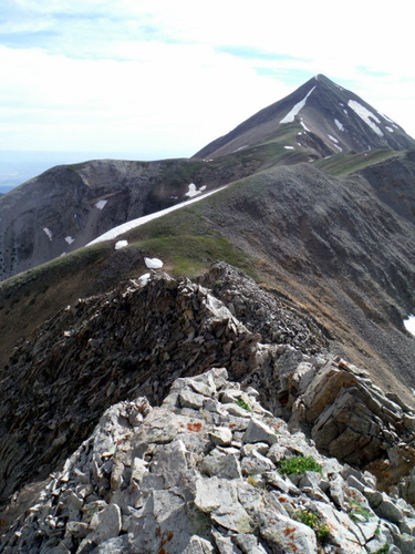
As I drove out of Moab the scratchy FM signal began to fade. It was time to change the station and settle down for the 4hr drive home, back to Salt Lake City after a quick but fulfilling adventure. An ad on the radio reminded listeners why they should come to this part of Utah. “Moab’s unique combination of beautiful redrock scenery, two national parks, and the allure of the Colorado River has made it one of the top adventure destinations in the West.” Interestingly, no mention of the utterly fantastic mountain range less than 15 miles to the east, the La Sal Mountains!
Getting to know the La Sals better has long been a goal of mine. A linkup of the 12 thousand foot peaks (“12ers”), of which there are 9 with 300′ or more of prominence, seemed like a great excuse. I had mapped the route out several years ago, but the project had remained on the shelf. When Jason Dorais and an army of other strong skimo dudes strung together a south-north route on skis in March my mind started scheming. On Friday (6/20/2014) when Bryon Powell responded to an email telling me that the conditions looked perfect, the decision was made as to what I would be doing on the solstice.
This would be a solo trip, which meant that a shuttle would be tricky. So, I modified the mostly north-to-south linkup and made it a loop, returning via a series of lower trails on the western side of the range to get back to my car. Other than operating at about -1.5dB (i.e. a bit sick) due to a week-long illness, the adventure could not have been more perfect. If you’re into endless talus fields, stunning views, frolicking through aspen trees, and a bit of route finding, I highly recommend this route. It’s ~36 mile and 15kft of up:
For an aerial perspective (via Google Earth), click on the image below:
And, below are some highlight photos from the trip:


I have noticed you don’t monetize your blog, don’t waste your traffic, you
can earn extra bucks every month because you’ve got high quality content.
If you want to know how to make extra bucks, search for: Mrdalekjd methods for $$$
By: FirstPoppy on October 6, 2017
at 1:12 pm
[…] La Sal Linkup – Finally made it down for this treasure. Linked together the nine 12,000′ peaks in the La Sal Mtns of south-eastern Utah. The views stunning. Red-rock beauty far below and in all directions. Story […]
By: 2014 – ReCap of the Best Year Ever | Jared Campbell's Blog on January 30, 2015
at 10:35 pm
Hey Jared,
Nice effort at Barkley Marathons your clearly a very sick man! I’m not that bright where, when and how do I enter?
Thanks a bunch
Adam Keen
Akeen74@hotmail.com
By: akeen74 on September 6, 2014
at 10:27 am
Hey Jared:
I would love to attempt this in the fall. It looks like inbetween Mt. Tom and Mt Mellenthin you cross through some potential water sources like a creek or lake. Can you confirm or deny that water would be available on the non ridge portions assuming we had means of purification?
By: spence on August 26, 2014
at 11:39 am